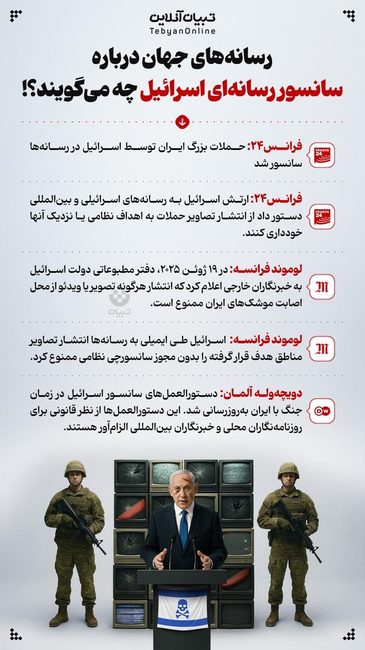
• Counter :
  • 5767
  • Date :
  • 5/2/2007

Geography and Nature

of Iran

Covering an area of 1,648,000 square kilometers, the Islamic Republic of Iran is located in southwestern Asia. The Caspian Sea, Turkmenistan, Azerbaijan and Armenia in the north; Afqanistan and Pakistan in the east; Turkey and Iraq in the west surround the country. On the south Iran borders the Persian Gulf and the Sea of Oman. Total terrestrial borders of the country are 5,170 km. and total water borders are 2,510 km.

Caspian Sea, Gilan

Iran is situated at the heart of the Middle East and, as a bridge, links the Caspian Sea, the largest land-locked body of water in the world, to the Persian Gulf. It is also a crossroad between the East and the West. Thus, historically, Iran has been in the juncture of cultural, intellectual and political manifestations of both the East and the West, while preserving it"s unique identity.

Unique landscapes such as limpid water springs, pomegranate orchards, pistachio gardens, rows of lombardy poplars, decampment of nomads in different seasons, stelliferous nights, rocky mountains, endless high and low lands, extinct snow-clad volcanoes, dense forests of the Alborz Mountain Range, and coastlines of the Caspian Sea, the Persian Gulf and the Sea of Oman are all eye-catching and memorable.

Abumoosa Island

Iran"s landscapes vary remarkably at different seasons. They are at times full of stone and sand, at times full of floodwater, sometimes covered by snow or by lush vegetation. Iranian artists have portrayed Iran"s nature as a sign of diversity and charm in their different and diverse artistic works. Iranians also have traditionally valued Water as a symbol of life and development. Innumerable permanent streams can be seen flowing in meadows, gardens, orchards, homes, mosques and sacred places irrigating trees.Nature and it"s diversity in Iran are valuable parameters for development of the tourism industry. In total, it is estimated that 19 million hectares of terrestrial land are covered by orchards, gardens and farmlands; 10 million hectares are plain and pastures; 19 million hectares are forests; and the remaining include barren lands, desert, and mountains.

Chaloos Forests, Chaloos

Among significant characteristics of the vast land of Iran is the existence of high mountains as well as flat plains, desert areas, rivers and lakes contributing to unique geographical conditions in which, at any time of the year, and in each section of the country, one of the four seasons is visible. Thus, in winter, swimming and water skiing are possible in the warm waters of the Persian Gulf, and at the same time winter sports, like skiing are possible in the northern and western mountains of the country, while one can enjoy the pleasant spring weather along the shores of the Caspian Sea- at the same time of the year.

The high Alborz Mountains, sealing off the narrow Caspian strip, are covered with dense forests and lush vegetation which have to be crossed when traveling to northern Iran.

The coastline of the Persian Gulf in the south is rocky and mountainous in some areas and sandy and swampy in others; it is not as even as the northern shores of the country. The southern provinces of Iran, specially Khuzestan, which encompass some parts of vast Mesopotamia (between two rivers) plain, are very flat and level with low altitude. If one walks in the northern or western mountains of Iran, he/she will be able to see so many eye-catching views and towns, villages, orchards, gardens and meadows with an amazing landscape. In any case, Iran has many amazing landscapes in very unexpected places.

Deserts , Kerman

The overall elevation of the plateau of Iran give many provinces an altitude of over 1,000 m., and this is an important geographic feature of this land. The magnificent Alborz Mountain Range in the north, the Zagross Mountain Range in the west and some other mountain chains, which extend from Khorassan to Baluchestan in the east, surrounded plateau of Iran which is mostly desert in the middle.. The most important summits in Iran are: Damavand (5,671 m.) northeast of Tehran; Sabalan (4,880 m.) west of Ardabil; Sahand (3,707) in the south of Tabriz; Takht-e-Solaiman (4,820 m.) in Chaloos; Zardkooh (4,550 m.) in Bakhtiyari; Dena (4,309 m.) north of Yasooj; and Taftan (3,941 m.) south of Khash.

Damavand Mountain, Tehran

Complexity and diversity of geological and calcareous structures have contributeded to the formation of so many caves in different provinces, specially in Azarbayjan, Kurdestan, and Hamadan, which are attractive to numerous tourists. Visiting some of these caves is highly recommended and they are amongst important tourism attractions.

The mountains of Iran belong to the folding of the Cenozoic Period and some of them, with volcanic origins, have brought about the means of formation of thermal springs. They have created suitable conditions for winter and mountain sports. The two well-known deserts of Iran, Dasht-e-Loot and Dasht-e-Kavir, covering an area of over 360,000 square kilometers, are amongst the most interesting yet unknown places. With more than 500 known mineral water and thermal springs used for different purposes, Iran has an important potential in this regard. Most of these springs are located in the Alborz Mountain Range, in Azarbayjan and in the Zagross Mountain and some are located close to Esfahan, Mashad and Bandar Abbas. The thermal springs of Sar Ein (Ardabil), Larijan (at the slopes of Alborz), and Mahalat attract many people all around the year for recreation and therapeutic purposes.

Desert

 The coasts of the Caspian Sea, with pleasant sandy beaches, are among the most important tourist attractions in Iran. Moreover, the southern shores and islands of Iran have their own natural beauty and being used as tourism attractions specially in winter. The slopes of Alborz and Zagross Mountains with numerous springs, lakes and wetlands have their own beautiful and eye-catching landscapes.

Climate

Iran is situated in the global arid zone and the Plateau of Iran enjoys a relatively dry climate. Alborz and Zagross mountain chains trap the humidity and air currents of the Caspian Sea and the Mediterranean climate preventing them from penetration to the inner parts. Iran, due to its location between 25 and 40 degrees latitude as well as its mountains, Iran enjoys considerably variable climates. The average annual temperature increases from the northwest to the southeast throughout the country and varies from 10? C in Azarbayjan to 25-30? C in the south and southeast in the same season. The northern and southern shores of Iran have diverse climatic conditions compared with the central and mountainous regions. For example, the average annual temperature of Bandar Abbas in southern Iran is 18.5? C in January. Difference of average annual rainfall is also very high in different parts of the country varying from 2,000 mm. in Gilan to less than 100 mm. in the central parts of Iran. Average annual precipitation in Iran is about 275 mm. 

A View of Alborz Mountains, Tehran

In January and February, there are three climatic zones in Iran. Shores of the Caspian Sea have mild and relatively cold weather, central parts have typical winter weather, and southern parts enjoy moderate and pleasant weather. Most regions of Iran enjoy pleasant weather in the spring, specially in April. However, the weather in southern regions of Iran grows very hot unexpectedly as early as March.

The climatic conditions of the country become more diverse in the summer. Due to high humidity, the weather at the Caspian Sea coast is hot during the day, but it is pleasant at night. In the southern coastlines of Iran, days are very hot and nights are relatively warm with high humidity, which can be intolerable by non-natives. It is therefore recommended that tourists choose their travel destinations while taking the weather conditions into account. The best season for travelling to Iran is spring. However, in every season there are provinces which are more favorable than others from climatic point of view.

The cities of Shiraz, Esfahan, Mashad, Tehran and Tabriz, which are the main tourism centers of Iran, enjoy different climates. Shiraz, with four months of warmth, ranks first and Tabriz, with only one month of warmth, ranks last. Azarbayjan, Kurdestan, Hamadan and Khorassan provinces are known as cool places in the summer.

A Natural Landscape of Fars Recreation Sites

In general, the entire northern part of the country, specially the northern slopes of Alborz Mountains, like Noor Valley, Kelardasht, Katalem, as well as provinces such as Azarbayjan and Khorassan and central regions of the Zagross Mountains - between Towiserkan and Golpayegan - are very popular destinations for week-ends and holidays by domestic as well as foreign tourists in the summer. Tourists may use the southern regions of Iran 5-6 months of the year, specially in winters.

Tourists, who visit the southern coasts of Iran in winter, can enjoy very pleasant weather; while at the same time the cities of Esfahan and Fars provinces are rainy and snowy. In general, in the summer, the weather in most parts of the country is warm but not intolerable. Spring and autumn are a suitable time for touring all around the country. Hotels are usually booked up during national holidays for Norooz (Iranian New Year starting March 21st).

  • Print

    Send to a friend

    Comment (0)